
Walk a Kanawha County Street
A Kanawha County street directory is built one official record at a time. The assessor identifies deeded ownership, while the GIS viewer shows how parcels sit beside roads and each other. Deeds carry the ownership trail backward. Voter records and historical directories may add evidence about a known person, but no public source lists every person who lives behind each door.
Start with the physical address, not the tax mailing address. Keep spelling variants for directions and road types, plus the district, parcel ID, and legal description. Those facts help when Charleston postal labels, unincorporated communities, or changed address forms make the first query fail.
- Enter the parcel address in the Kanawha assessor; try shorter forms or a nearby number if needed.
- Open the parcel map and move along the street, one tax polygon at a time.
- Record owner, situs address, mailing address, parcel ID, district, sales history, and deed book/page.
- Take the deed reference to the County Clerk, then follow grantor and grantee names backward.
- Use a voter query or Polk directory only when a known name or historical year makes that source fit.
Search Kanawha Streets by Address
The Kanawha County Assessor search accepts any combination of criteria. For a street directory search, Parcel Address is the natural start. Owner names use LAST NAME FIRST NAME without commas. The account number is eight digits. District, map, parcel, subparcel, and special identifier are separate fields. Legal description and deed book/page give alternate paths when the address is weak.
The assessor image shows the official fields. It helps explain why the county street directory can move both from an address to an owner and from a deed citation back to a parcel.
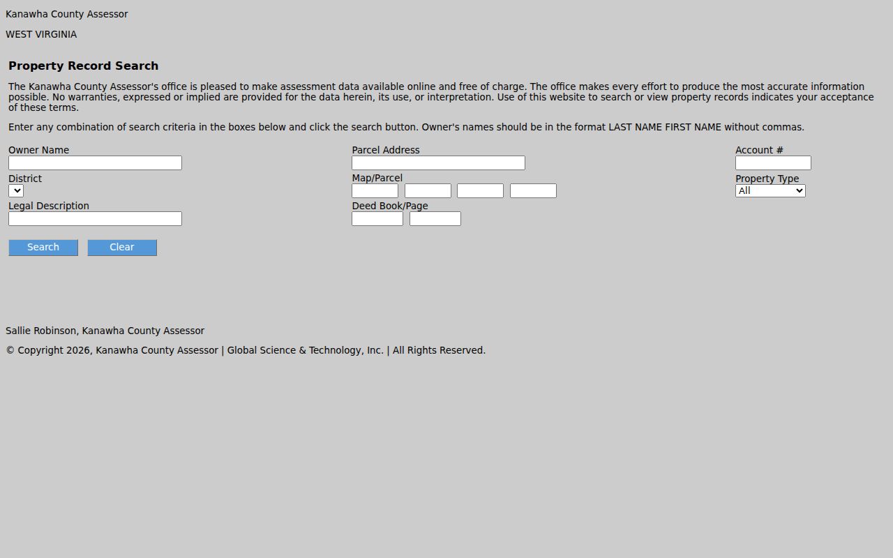
A result may include current owner, tax mailing address, physical or E-911 address, tax district, parcel ID, legal description, values, sales, improvements, building card, and flood information. Save the original labels.
| Field | Input | Street use |
|---|---|---|
| Parcel Address | Address text | Find one site |
| Owner Name | LAST NAME FIRST NAME | Find related parcels |
| District and Map | Coded fields | Separate repeated road names |
| Parcel/Subparcel | Up to four characters | Return to the exact tax unit |
| Legal Description | Up to 50 characters | Bridge an address change |
| Deed Book/Page | Up to five characters | Connect the recorded transfer |
Map Kanawha County Street Parcels
The county parcel viewer supplies tax-map context, and the WV Property Viewer adds roads, topography, imagery, address numbers, and flood zones. Find the first parcel, zoom to the street segment, click each adjacent polygon, and open its detail. There is no researched basis for promising a one-click radius or neighbor report.
The statewide result can show Root Parcel ID, current owner, property address, county, district, map, parcel, deeded acreage, class, use, and appraisal figures. It can also export a result table. Map lines serve assessment work and are not a legal survey. Water, a right-of-way, undeveloped land, or a map artifact may explain a visible gap.
The official MapWV assessment view below shows the parcel-based interface used to connect street geography with record detail.
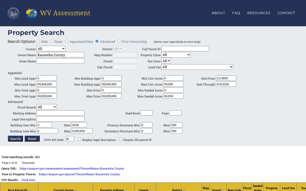
Follow each parcel link rather than treating a pin or address point as a separate owner.
Kanawha Mailing and Situs Addresses
The most important street directory distinction is mailing versus situs. The owner mailing address is where tax notices go. It can be a post office box, an agent, or a different city or state. The situs, property, or E-911 address marks the physical parcel. County GIS specifications explicitly describe the physical address as the parcel location, not the owner address.
One MapWV parcel can carry several E-911 addresses, such as apartments or alternate access points. That does not mean each number has a different owner. The reverse is also possible: one owner may hold several adjoining parcels. Track owner, parcel, building, unit, and occupant as separate concepts. This local quirk prevents a by-address search from inflating the number of households.
- Parcel
- A unit of land identified for assessment.
- Situs address
- The physical location of the assessed land or building.
- Plat
- A recorded drawing that lays out lots, boundaries, or a subdivision.
- Criss-cross directory
- A historical directory arranged by street or address.
Kanawha Records Keyed by Street
Each address source reveals a different layer. The street directory becomes reliable only when the source is described as narrowly as its keeper intended.
| Record set | Keeper | What it shows | Access |
|---|---|---|---|
| Assessment parcel | Kanawha Assessor | Owner, mailing and situs fields, values, sales | Free online |
| GIS tax map | Assessor and MapWV | Parcel sequence, roads, address points, flood context | Public map, not survey |
| Deed and index | County Clerk and Archives | Transfer parties, legal description, book/page | Record Room, counter, microfilm |
| Voter record | WV SOS and County Clerk | Known voter, residence, status, party, districts | Person lookup or data request |
| City permit | Charleston Development Services | Owner, contractor, project, inspection, address | Counter, phone, FOIA |
| Polk directory | KCPL | Historical occupants and addresses | In library, 1908-present run |
| Sanborn map | Library of Congress | Historic building footprint and use | Free 1902 images |
Current ownership leads to deeds, while an old occupant leads to directories and newspapers. Do not force all sources into one date.
Follow Deeds Along Kanawha Streets
A deed chain begins with the assessor sales history and book/page reference. Take that citation to the Kanawha County Clerk Record Room at 409 Virginia Street East or call 304-357-0240. The current county page describes recording work but does not provide a live deed-index URL or online cutoff. Counter, phone, and a specific written request are the required fallbacks.
In a deed, the grantor transfers property and the grantee receives it. Identify the seller on the newest deed, then search that person as an earlier grantee. Record the date, parties, document type, consideration, book/page, lot and block, parcel clue, and releases or liens. The legal description is often a steadier bridge than the house number.
Archives microfilm has deeds from 1790-1910, grantor indexes from 1790-1946, and grantee indexes from 1795-1967. Those ranges guide a search but do not promise that every volume survives. Ask the Clerk or Archives about a gap.
Kanawha Permits by Address
Charleston Development Services can add construction evidence to the county street directory. Permit and inspection files may carry the owner name, property address, contact phone, contractor, permit number, project type, and dates. Projects include new work, remodeling, additions, repairs, roofs, windows, signs, utilities, and right-of-way excavation.
No official public permit-by-address search was located. Contact Development Services at 304-348-6833, visit the permit counter at 915 Quarrier Street, Suite 5, or send a focused West Virginia Freedom of Information Act request. Inspection requests require at least 24 hours notice, but that operating rule does not imply instant archival research. Code Enforcement at Suite 3 also uses assessment ownership for notices. A permit holder or contractor is not proof of occupancy.
Voter Evidence on Kanawha Streets
The public GoVoteWV lookup is person-first, not street-first. It requires first name, last name, and date of birth. A match may show status, party, political districts, and polling place. It cannot browse every person at one address. The system updates nightly and lists a midnight-to-2 a.m. maintenance window.
A lawful voter-data request can include residence address, county, party, status, registration date, precinct, districts, and optional mailing address. Social Security numbers, state-ID or license numbers, phone numbers, and email addresses are withheld. Protected voters and Address Confidentiality Program participants receive added protection. Registration confirms one official voter record, not every occupant of the home.
Old Kanawha Streets in Directories
The Kanawha County Public Library lists Polk Charleston directories from 1908 to the present. For an older street, confirm onsite whether the needed volume has a reverse or criss-cross section. Read the exact street heading, directions, cross streets, house numbers, abbreviations, and nearby entries. The complete historical shelf belongs in the Kanawha County city directory collections.
Directory evidence can name a householder, spouse, occupation, employer, or address for one publication year. Pair it with a deed or census rather than treating it as an unbroken occupancy record. The Library of Congress 1902 Charleston Sanborn maps date buildings and uses, not residents. KCPL newspaper microfilm can add obituaries, but the Daily Mail run from 1914 and Gazette run from 1924 are not indexed.
Street Geography Across Kanawha County
Kanawha roads pass from Charleston valley neighborhoods into separate municipalities and unincorporated communities. A street search can cross tax districts, ZIP delivery areas, municipal lines, ridges, and flood zones without leaving the county. Kanawha City is a Charleston neighborhood with a strong 25304 postal identity. Cross Lanes, Sissonville, and Big Chimney may also appear under postal labels that do not match local identity.
ZIP codes route mail; they do not define city limits or create a resident roll. The assessor form has no ZIP field. MapWV can return the physical city, state, and ZIP and export results, while the USPS lookup verifies delivery ZIP for one full address. Preserve tax district, mailing city, municipality, and ZIP as separate facts.
Insider tip. If an address fails, try the road without its direction or type, search a nearby number, and browse the GIS segment.
Limits of Kanawha Street Directories
A public street directory cannot show every renter, roommate, child, guest, or unlisted household member. Utility and delivery accounts are not open resident rolls. Motor-vehicle addresses are restricted. A permit identifies project parties, not everyone living there. A tax exemption may support an occupancy clue, but its absence does not disprove residence.
Commercial neighbor tools can merge old marketing files, public records, and user corrections. Their broad reports may be stale or join two people. Use them only as leads, never as proof. Official records are narrower, dated, and tied to a named custodian.
Lawful use. Kanawha County address records may be used for lawful personal research, never to stalk, harass, intimidate, or harm anyone.
West Virginia Address Confidentiality Program participants may use a substitute address in government transactions. Respect protected addresses and sealed records. When safety is in doubt, stop the search rather than trying to defeat a privacy safeguard.